


DBFP (Database for Forest Planning)
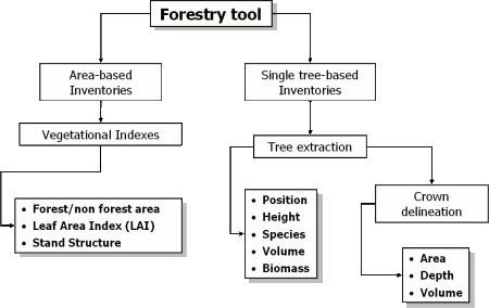
The DBFP is the georeferenced, three dimensional, GIS database built starting from laser scanning data that contains all those parameters you need for the monitoring of forested areas. These parameters concern both morphological and biomass indicators about single trees and whole forested areas. The DBFP is produced using owning methodologies of data processing (Forestry tool).
DBFP highlights
- Accurate information on vast forested areas, faster and easier than traditional measurement campaigns
- High quality/price ratio
- Population statistics over whole areas by GIS standard operators (e.g. population density, average hight of forest, forest volume, species distribution, differential age ecc.)
- Monitoring of biodiversity, biomass distribution, forestry and land use changes, and habitats
- Stand structure assessment (mono/bi/multi storeyed forests) useful in order to understand:
- Old management processes
- Presence/absence of low vegetation (renewal processes)
- Fire risk
Virtual forest
The DBFP enables you the visual exploration of your forestry dataset. This 3D virtual representation is a powerful tool to intuitively understand the forestry landscape and it is a very helpful instrument for the forestry management and planning.
Versatility
Our methods of laser scanning data processing were already tested in the Alpine ecosystems showing very high degree of accuracy. Moreover, the Tree Extraction test held during 2006 highlighted the effectiveness of the DBFP also in context of boreal forests.
Technical characteristics
The DBFP is delivered in Shape file, the most common and used GIS interchange format. However it is possible to customize the output format, depending on the customer requirement.